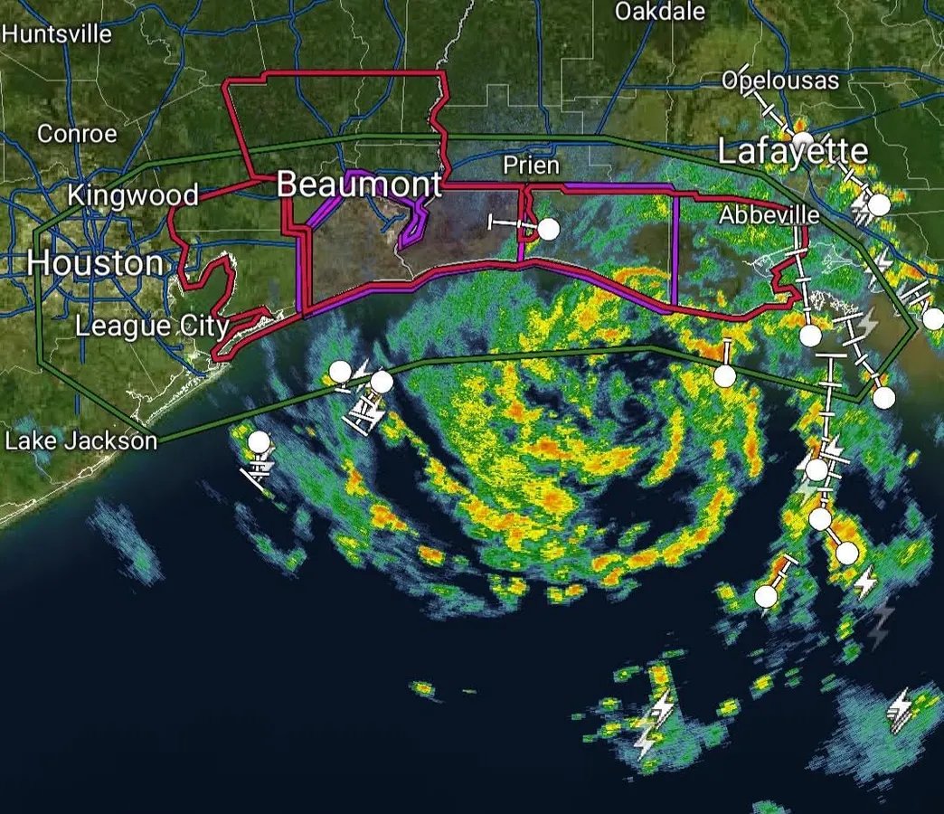
Strengthening Tropical Storm Edouard On The Verge Of U.S. Landfall

Tropical Storm Edouard approaching the U.S. Gulf Coast on Tuesday September 1, 2026.
NOAA and Tropical Tidbits
Tropical Storm Edouard has formed in the Gulf and will make landfall later today along the southeastern coast of Texas. While the storm will be relatively short-lived, it could flirt with becoming a hurricane later today as it makes landfall near the Texas – Louisiana border. Here’s what to know right now.
Current Status Of Tropical Storm Edouard
The National Hurricane Center has been watching the storm closely over the past few days. “Although it only has about a day over the very warm Gulf waters, strengthening is expected within a generally low shear environment,” wrote National Hurricane Center forecasters on Monday afternoon. At that time, the storm was a Tropical Depression. The small size of the storm made it more likely to intensify given the favorable conditions for development.
“The intensity forecast today is problematic. Edouard has managed to develop a small core that could be prone to rapid changes in intensity,” noted NHC forecasters early Tuesday morning. They are not ruling out the possibility of the storm reaching a Category 1 hurricane intensity. Even if not, it will be an impactful high-end tropical storm event. At the time of wroting at 4:15 am Central Time, the storm was moving west-northwestward at 8 miles per hour with sustained winds of 40 miles per hour.
Forecast track for Tropical Storm Edouard.
NOAA and NWS
What’s Expected?
A strong tropical storm or even Category 1 hurricane will bring impacts to the Upper Texas and southwestern Louisiana coasts, east-central Texas, and southwestern Louisiana on Tuesday and Wednesday. According to NHC, “A Storm Surge Warning is in effect for High Island to the Vermilion/Cameron Parish Line. Tropical Storm Watch is up from Port Bolivar to the Vermilion/Iberia Parish Line. In case the storm continues to strengthen, a Hurricane Watch is in effect for High Island to Cameron, Louisiana.
Edouard is expected to make landfall near the Texas and Louisiana border, which keeps the center of the storm and its worst conditions east of the Houston metropolitan area. The most likely impacts will be related to rainfall as both flash and river flooding are possible. Up to 4 feet of storm surge is also possible from western Louisiana to High Island, Texas.
Tropical Storm Edouard is the fifth named storm of the Atlantic hurricane season. Typically, the fifth named storm of the year happens around August 22nd. Forecasters have called for below-normal activity due to El Niño. The Atlantic basin has been relatively quiet. As we enter the month of September and the first day of meteorological fall, the Atlantic season activity typically ramps up. The peak of the season is around the second week in September.
Atlantic Hurricane and Tropical Storm Activity.
NOAA and NWS
As Edouard produces rain in the region, the remnant moisture from Tropical Storm Dolly provided much needed relief for drought-stricken Puerto Rico. Parts of Texas have also been in drought conditions, so rainfall is needed. However, 3 to 6 inches of rainfall falling on dry conditions will certainly produce flood hazards for the region. It’s a bit of a “Jekyll and Hyde” situation. However, our NASA-sponsored research at the University of Georgia has shown that these are the perfect drought-busters. “Shepherd and colleagues found that while major hurricanes (Category 3, 4, or 5) dump more rain in a single day than other storms, weaker hurricanes, tropical storms, and depressions contribute more to the cumulative total throughout the hurricane season,” said a NASA press release.
Expected rainfall from Edouard.
NOAA